The NSW Government's Flood Prone Land Policy makes Council responsible for managing flood-prone lands in its area. Council must make Floodplain Risk Management Plans to manage flood risks under this policy.
The main aim is to lessen flooding's impact on property owners and occupants. The plan also seeks to reduce losses from floods for everyone, using good flood prevention methods.
If you need information or support after a flood, visit our Community Support Services Directory.
Flooding in Georges River Council
Like other urban areas in New South Wales, Georges River Council has a history of flooding.
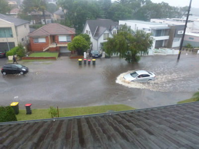
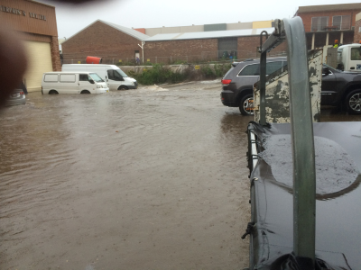
Floods happen when water covers normally dry land. This usually occurs because of weather systems that produce heavy rainfall. Flooding can be due to water flowing within, out of, or towards a waterway.
In Georges River Council, there are three main types of flooding:
-
Overland flash flooding: happens when stormwater pipes and channels overflow. This excess water then spreads across the land and flows into waterways.
-
Mainstream flooding: when water levels in creeks and rivers rise. Spilling over their banks and covering the nearby land.
-
Coastal flooding: flooding of low-lying coastal areas. Due to a combination of high tides, storm surges, and waves.
Different types of flooding can occur in isolation or in combination. When these flood events coincide, extreme/rare flooding can occur.
Is my property flood prone?
Find out if your property is prone to flooding with these tools:
-
Online Flood Maps: a flood-prone land map shows the lots that are in risk of 1% AEP and PMF flood event.
-
Flood studies and floodplain risk management studies and plans: refer to the Completed Studies section below. This includes detailed flood behaviour and flood risks.
-
Flood Level Advice: contact us for flood information specific to an individual property.
-
Section 10.7 Certificate: This shows if a property is in the Flood Planning Area. It also shows if the land is between the Flood Planning Area and the PMF flood-affected area.
Contact the Stormwater Asset Engineering Unit on (02) 9330 6400 to check if flood information is available for your property. You can also send your enquiry by email to mail@georgesriver.nsw.gov.au.
How can I lodge a flood advice application?
-
Online: you can lodge your application using Georges River Councils Log It/Fix It page. Select the Stormwater Flood Level Enquiry. Customer service centre will then contact you for the payment.
-
In person: at Council’s Customer Service Centres. Corner MacMahon and Dora Streets, Hurstville. (Monday to Friday 8.30am - 5.00pm).
-
Contact us: visit our contact us page, call (02) 9330 6400 or send your enquiry via email: mail@georgesriver.nsw.gov.au.
How can I get access to Council’s Flood Model and Data to undertake Flood Impact Study?
You must use the Council’s Flood Model and Data to prepare a flood impact study for a development proposal. This information helps create a computerised flood model. It shows how the development affects the floodplain. Council can give access to the two-dimensional Flood Model. This requires paying a fee and signing a data agreement.
Council can provide access to the adopted two-dimensional Flood Model, subject to the payment of a fee and data agreement signing.
-
Online: you can lodge your application using Georges River Councils Log It/Fix It page. Select the 2D Model and Data Request. Once reviewed customer service will then contact you to make the payment.
-
In person: at Council’s Customer Service Centres. Corner MacMahon and Dora Streets, Hurstville. (Monday to Friday 8.30am - 5.00pm).
-
Contact us: visit our contact us page, call (02) 9330 6400 or send your email enquiry to mail@georgesriver.nsw.gov.au.
Preparing for and responding to flash flooding
Flash floods are dangerous and can happen anywhere there is localised heavy rainfall. There may be no official warning for flash floods.
Heavy rainfall and pooling or rushing water are natural indicators of flash flooding. It's crucial to remember that flash floodwater can be swifter and deeper than it seems. It can also contain sewage and poisons, hidden snags, dead animals and debris. The major cause of death during flash floods is by people entering flash floodwater.
If you come across a flooded road, stop and turn back. Never drive, ride or walk through floodwater.
Find more information from NSW SES and Insurance Council of Australia.
What should I do in the event of a flood?
If the situation is life threatening you should call 000 immediately. In an emergency like a flood, storm, or tsunami, call the NSW State Emergency Service (SES) at 132 500 for help. You can also visit the NSW SES website.
It is best to be prepared for any flood. The State Emergency Service also provides advice on how to manage your flood risk.
Completed Flood Studies and Floodplain Risk Management Studies and Plans
Council has completed flood studies for the entire Local Government Area. These are undertaken by specialist flooding consultants. They use up-to-date data, flood modelling software and floodplain risk management guidelines.
These studies are a part of the Floodplain Risk Management Process. They provide a comprehensive technical investigation of flood behaviour within the area.
Council has completed a floodplain risk management study and plan for Hurstville, Mortdale and Peakhurst Wards.
You can use the tabs below for more information and to download the flood studies.
-
Blakehurst and Kogarah Bay Wards Overland Flow Flood Study
In April 2026 , Council endorsed the Blakehurst and Kogarah Bay Wards Overland Flow Flood Study.
-
Hurstville, Mortdale and Peakhurst Wards: Overland Flow Floodplain Risk Management Study
In 2016, Council adopted the Overland Flow Flood Study for the Hurstville, Mortdale and Peakhurst Wards. Following that, Council engaged a consultant to prepare the Floodplain Risk Management Study and Plan in 2019 to identify floodplain risk mitigation options.
In October 2023, Council endorsed the Overland Flow Floodplain Risk Management Study and Plan for the Hurstville, Mortdale and Peakhurst Wards catchment.
Download links:
Flood maps:
Current Flood Studies and Floodplain Risk Management Studies and Plans
Managing Floodplains and Risk
Preventing floods is tough, but we can manage risks by planning and using floodplain strategies.
The NSW State Government’s Flood Policy helps us use floodplain areas sustainably. It helps solve existing flood issues in both rural and urban places. The Policy ensures new development doesn't worsen flooding elsewhere.
Under the Policy, the management of flood liable land remains the responsibility of local government. We follow the NSW Government’s Flood Prone Land Policy from the 2023 Flood Risk Management Manual to manage flood risk.
The Floodplain Risk Management Committee at Council manages floodplain risks. It includes members from the Council, NSW Government, and the community. The NSW Government helps with technical and financial support through its Floodplain Management Program. Council is also supported by Floodplain Management Australia.
Council’s floodplain management program has been in operation for many years. Studies measure flooding levels. Then, management actions are assessed, recommended, and put into place.
Community Consultation
Community consultation is important. It plays a key role at every stage of the Floodplain Risk Management process. Residents are invited to give their views on flooding issues. They can also suggest potential measures for flood management.
Our Floodplain Risk Management Committee also includes community representation.
Frequently Asked Questions
-
Why do Councils study overland flooding?
Severe flooding, triggered by intense rainfall, leads to overland or flash flooding. Floodwaters can cause significant damage to homes, businesses, and human life.
Flood Studies help us understand floods better. Providing tools for planning land use, responding to emergencies, and prioritising infrastructure.
The NSW State Government's Flood Prone Land Policy requires councils to find and deal with areas prone to flooding. They work to reduce risks to people and property from floods and must share this information with the community.
Local Governments must act under the NSW Flood Prone Land Policy. This aims to lessen flooding impact and liability on property owners and occupants. Increasing awareness about flooding helps people understand and plan for flood risks better.
-
What is an overland flood study?
An overland flood study is a comprehensive technical investigation of flood behaviour.
It tells us how much flooding happens in an area. Giving details about where floods go, how much water there is, and how fast it moves during floods.
This study is the first step of the NSW State Government's Flood Prone Land Policy. It happens before a Floodplain Risk Management Study & Plan, which looks into flood risks and ways to reduce them.
The study will find out which properties might flood and help plan how to stop it from happening.
-
What is the Floodplain Risk Management Process and Steps
The Floodplain Management Process has four main steps in the Floodplain Management Process:
-
Flood Study. This aims to find out how floods happen. Including where they flood, how deep the water is, the danger, and how likely flooding is in the area.
-
Floodplain Risk Management Study. This builds on the flood study to look at how flooding will affect the community. Identifying ways to reduce the impact of flooding.
-
Floodplain Risk Management Plan. Includes preferred flood mitigation options to manage flood risk across the catchment. Council adopts these options.
-
Plan Implementation. After planning and availability of funds, we implement the selected options. These options may include fixing problems, improving drains, setting rules for building, raising awareness, and getting ready for emergencies.
The primary aim of a Flood Study is to assess the characteristics and risk of flooding in a specific area. Through a Flood Study, Council prepares flood mapping across the study area including the number of lots that are “Flood Tagged”. Flood Tagging identifies properties at risk of flooding. It helps enforce development controls to protect against floods.
The next step involves conducting a Floodplain Risk Management Study and Plan. This study aims to find ways to reduce flooding risks for people and properties in the area. It includes options like building things to lower flood levels, making rules for development, teaching people, and improving how we handle emergencies. We share flood information with the public after we're sure our flood models are reliable.
-
What is the difference between a Flood Study, Floodplain Management Study and a Plan?
The Flood Study is a technical investigation of flood behaviour.
The Floodplain Risk Management Study and Plan investigates strategies to manage flood risk and lessen flooding impacts on the community. These impacts may cause property damage, financial loss, inconvenience, and personal danger.
-
What is the 1% AEP (1 in 100 year) flood?
A 1% Annual Exceedance Probabilit (AEP) flood has a 1% or 1 in 100 chance of being reached or exceeded in any given year.
Some parts of Australia have experienced more than one ‘1 in 100 year’ floods within a decade of each other. Within the Floodplain Risk Management Study and Plan the ‘1 in 100 year’ flood is referred to as the 1% AEP flood event.
-
What is the Flood Planning Area?
The Flood Planning Area (FPA) is the area of land below the Flood Planning Level (FPL).
The FPA is generally developed based on the FPL for typical residential development. Different types of development may have different FPLs applied within the FPA. In addition, development controls may vary across the FPA due to varying flood constraints.
-
What is the Flood Planning level?
The Flood Planning Level (FPL) is the height used to set floor levels for houses in flood prone areas. It is generally defined as the "1% AEP flood level" plus and appropriate freeboard. See the explanation of 'freeboard' below.
The FPL can be calculated as:
FPL = 1% AEP flood level + freeboard.
-
What is Freeboard?
A freeboard is an extra height above the flood level during floods. It is included in the Flood Planning Level. This extra height helps deal with wind, waves, unforeseen blockages, and other local water effects.
-
How are flood affected properties identified?
Council’s flood modelling determines the extent of flooding in the catchment and the properties affected. Section 10.7 Planning Certificates identify if flood related development controls apply to the land.
-
What should I do in the event of a flood?
If the situation is life threatening you should call 000.
Contact NSW State Emergency Service (SES) at 132 500 or visit the SES website for help during floods, storms, or tsunamis.
Being prepared for any flood is crucial. The State Emergency Service provides advice on how to manage your flood risk.
-
What are Councils doing to manage flood risk?
Councils prepare Flood Studies and Floodplain Risk Management Studies and Plans based on the NSW Government's Floodplain Development Manual (2005) guidelines. We use technical and financial help from the NSW Department of Planning Industry and Environment. These plans include suggestions to reduce flooding impacts on residents and businesses in the study area.
The council implements top-priority options from the Floodplain Risk Management Plans. This is to lower flood risks. It's based on detailed feasibility studies and available funding.
-
How are flood risks managed?
There are three main ways of managing flood risk:
-
Flood modification – this approach looks at changing the flood behaviour using structures such as detention basins or drainage system improvements.
-
Property modification – this approach includes modification to existing properties and seeks to better manage future development through land use planning.
-
Response modification – this approach focuses on increasing our resilience through better preparedness, improved warning and recovery planning.
-
What does a Flood Study and Floodplain Risk Management Study and Plan mean for property owners?
Most people don't need to do anything about this Floodplain Risk Management Study and Plan. Yet, property owners planning redevelopment should think about how floods might affect their project.
This might mean setting the floor levels of the development at or above the Flood Planning Level. This helps reduce the impacts of flooding.
-
Does having a flood notation mean I can't develop my land?
It's unlikely that development controls will prohibit all development on flood prone land. Yet, some things need thinking about to keep people and property safe. For instance, you might have to build on a specific area of your land, raise your building to a certain height, or avoid building where flood risk is high.
Our Development Engineering team can help you understand these considerations. You can lodge an application for a flood advice letter to get the details of the flood risk of a property.
-
Does Flood Study and Floodplain Risk Management Study and Plan affect property values?
House prices vary with changes in the real estate market and are based on a large range of criteria. Such as location, size and age, and are not under the control of Council. It is the market that determines the value. This study does not prevent the sale or purchase of property.
Studies show that an actual flood event, rather than a flood planning notation on a Planning Certificate, is more likely to have an effect on property values.
-
Will this affect my insurance premiums?
Council doesn’t put together flood studies or floodplain risk management plans for, or on behalf of insurance companies. Flood Studies are a legal requirement for Council to complete and part of our responsibilities to help manage flood risk in the community. Insurance companies may rely on their own assessment of risk and can use their own methods to identify flood risk.
Individual insurance companies possess extensive data on flood risk obtained through their own flood studies and analyses which is already reflected in the cost of premiums, irrespective of whether Council has undertaken a flood study.
Further information on flood insurance is available from Flood Management Australia.
-
What is the Probable Maximum Flood?
The Probable Maximum Flood (PMF) calculates the biggest possible flood in an area by considering extreme conditions and probabilities.
It's rare and helps understand flood risks fully. It helps design critical and sensitive facilities. Such as hospitals, childcares, nursing homes, schools and emergency service facilities.
-
My property is on a hill and far from the river, why I am included in the study area?
When it rains a lot at the top of a hill, the water flows downhill through low spots like gullies and channels. Even if it's slower and less deep at the top, it can still cause floods and erosion downstream.
-
My property has never been flooded - why is it considered flood affected?
Floods do not occur in a regular pattern. There may be a period of no floods and a period of several floods. For example, the last time the Brisbane River flooded before the 2011 disaster was in 1974. Residents who moved there in more recent times may never considered flooding an issue until the floods in January 2011.
In 1949 and 1950 Kempsey experienced the two worst floods ever recorded, within eight months of each other. Following extensive rain every water course will flood.
-
I still don't think my property is flood affected? What can I do?
Members of the public can make a written submission to Council to raise flood related issues. You can provide your valuable feedback and comments by emailing Council.
-
The floor levels in my property are above the flood level - why has it been identified as flood affected?
Properties can be marked as being flood affected, under the Council’s policy. Regardless of the building's floor levels. This ensures that future developments match the Flood Planning Area and aren't constructed below the flood level.
Property owners or developers can seek flood level information from Council. For more details about applying for a flood advice letter, contact customer service at (02) 9330 6400 or email mail@georgesriver.nsw.gov.au.
-
Why can't council fix all flooding?
Council designs the piped stormwater system to handle frequent minor storms. This is to reduce everyday flooding.
During major storms, overland flow paths are used to protect life and property. Building piped drainage systems for major storms is impractical and costly.
-
Who is responsible for maintaining stormwater drainage system in a private property?
Property owners need to look after stormwater pipes, gutters, downpipes, and gully pits on their property. These must be in good condition and follow Council rules. If there's a stormwater easement on your property, keep it clear of blockages so water can flow freely.
Property owners must maintain the stormwater system on their property up to the kerb and gutter. If maintenance is needed within the footpath area, you need to apply for permission to work within the road reserve.
You can get applications at Council’s Customer Service Centre or on our Online Forms webpage.
-
Why overland surface flow from upstream property enters my property?
During rainfall, water will flow along the lowest points of the land. Allowing natural overland flow from neighbouring properties or public land is crucial. This water flow should not be diverted onto other properties.
Downstream property owners cannot block the flow of stormwater. If your property is downstream, you must accept the natural run-off onto your property.
Thank you for taking the time to share your feedback.