The Georges River area has a number of walkways and cycle routes which provide an easy way to explore the area. Many offer beautiful views of the Georges Rivers and our bushland reserves.
Whether you are looking for a short walk or a long distance route, there is something for everyone to enjoy.
Popular Walkways
- Carss Bush Park (Carss Park)
- H.V. Evatt Park to Salt Pan Creek walkway (Lugarno)
- Gannons Park to Boggywell Creek walkway (Peakhurst/Lugarno)
- Lime Kiln Bay to Hurstville Golf Course walkway (Mortdale)
- Lime Kiln Bay walkway (Peakhurst)
- Moore Reserve (Oatley)
- Oatley Park walkways
- Oatley Pleasure Grounds
- Oatley to Como Bridge walkway and cycle path
- Poulton Park (Connells Point)
- Salt Pan Creek and Riverwood Wetlands walkway (Riverwood).
If you would like to walk in a place where your dog can exercise without a leash, we have nine off-leash areas to choose from.
Cycle Routes
At Council, we encourage leisure and recreational cycling throughout the region. We have developed 11 cycling routes for the whole community to enjoy. By choosing to cycle you are reducing traffic congestion and air pollution, improving your health and fitness and saving money on petrol and travel fares.
Cycle routes can be found at the following locations:
- Carss Bush Park (Carss Park)
- Gannons Park (Peakhurst)
- Hurstville Oval (Velodrome)
- Kempt Field (Hurstville)
- Leighton Park (Beverley Park)
- Moore Reserve (Oatley)
- Oatley Park (Oatley)
- Oatley to Como Bridge (Oatley)
- Olds Park (Penshurst)
- Sans Souci Park (Sans Souci)
- Todd Park (Carss Park).
Cycling Tips
|
On-road cycling
|
The Georges River region has a network of on-road cycle paths. These are identified by logos painted on the left-hand side of the road, as well as the presence of signage. These warn motorists and pedestrians to ‘Watch for Cyclists.’
|
|
Off-road cycling
|
Off-road cycle routes in the local area enable cyclists to ride on a paved surface without interference from vehicles.
|
|
Shared paths
|
Shared paths are a popular choice for people who are looking for a motor-vehicle free route.
Pedestrians have priority on shared paths, and cyclists are required by law to ride to the left of the path. It is suggested that you ring your bicycle bell to warn pedestrians of your approach, especially if you are behind them.
Learn more about Shared Paths.
|
View the map showing the walkways and cycle routes throughout the Georges River area.
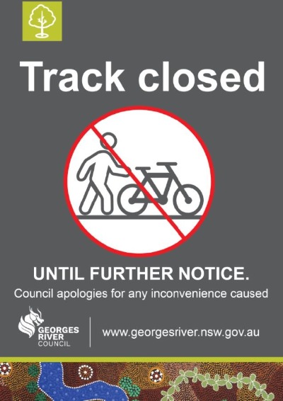
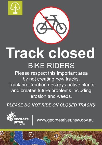
The following signage are examples of what is being installed. These show track closures and information regarding damage to bushland.
Frequently Asked Questions
Mountain Bike and BMX riding in Georges River
-
Where can I ride my off-road bike?
Off-road bikes, such as mountain bikes and BMX bikes can be ridden on roads, fire trails and in some of our parks on existing established tracks. To find out if it is permitted in any park check the park signage at the entrance to the park or the plan of management for the park.
We have a program to improve signage in our parks to assist all users which will indicate if bike riding is permissible.
The following map shows the location of all fire trails in the Georges River Local Government Area.
The following map shows the permissible locations for off-road biking and walking trails in Oatley Park.
-
Can I build jumps and other obstacles for my bike riding?
Council has decided to investigate suitable sites for a preferred long-term, permanent home for BMX and/or mountain bike facilities in Georges River. It will be some time before permanent facilities could be constructed.
However, Council is currently investigating short-term and interim measures to support the bike-riding community during the upcoming summer holiday period. These interim solutions will support bike riders during the current and future NSW Public Health Order restrictions and/or until the longer-term design and construction of an active recreation facility is completed.
A further report will go to the October 2021 meeting of Council to discuss the option for the short term provision for mountain bike riding facilities.
Until these interim and long-term studies and works are completed Council has adopted a policy position that involves only removing informally constructed bike tracks and jumps where tracks have potential to:
- Expose track users or nearby bystanders to harm and hazard; or
- Permanently degrade or significantly deteriorate environmentally sensitive bushland areas; or
- Interfere with other existing facilities within Council owned and/or managed parks.
-
Does Council propose to build a specialised mountain bike or BMX bike facility?
Council recently decided to investigate the feasibility for additional active recreation facilities including BMX and mountain bike facilities within Georges River.
A further report will go to the October 2021 meeting of Council to discuss the option for short term provision for mountain bike riding facilities.
The Plan of Management for the former Oatley Bowling Club site at River Road, Oatley also includes a pump track.
-
Can I create new tracks in the bush?
No, you cannot create new tracks or trails for any purpose. The creation of new tracks in bushland areas is prohibited.
This activity is harmful to the environment and may result in the destruction of endangered and native flora and the natural landscape. It may also pose a public safety issue for other park users.
-
What can I do if I see obstacles placed on existing tracks?
Any activity by the public which is designed to deliberately damage bikes and injure riders could constitute criminal activity. The dangerous practise of placing branches, logs, fishing line, trimmer cord and other obstacles across tracks is unacceptable. If you witness such action, you should immediately report it to the Police on 1800 333 000. If you find any obstacle and believe it may pose an immediate risk, and without putting yourself in danger, please try to move obstacle and let Council know.
You can report this to Council using the Log It/Fix It option on Council’s website or you can download the Georges River Council app from the App Store or Google Play. The app lets you easily take a photo and upload the details on Request a Service.
-
Who has right of way on tracks?
Cyclists must always give-way to pedestrians and bike riders should be aware of the potential danger posed to all park users of deliberately building jumps. We are improving the signage in parks to help all users understand their obligations to each other.
-
What can I do if I am threatened by another park user?
Any threatening or criminal behaviour by the public should be reported immediately to NSW Police. The Police are equipped to respond appropriately and ensure the safety of park users in the event of any immediate threat to personal safety. Council rangers and officers are unable to respond to reports of threats of violence.
You must not take photographs of children without the express written consent of their guardian or parent.
Thank you for your feedback.